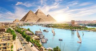
"Egypt was a ribbon of life. The cities clung to the riverbanks, for to step too far from the Nile was to step into the realm of death. Geography didn't just influence urban planning; it dictated it entirely."
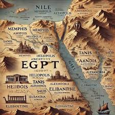
The population density of Ancient Egypt was entirely determined by the Nile's course. Great cities like Memphis, Thebes, and Heliopolis developed strictly along the riverbanks or canals. Life beyond the floodplain was impossible, creating a unique "linear civilization" that stretched for hundreds of miles but was often only a few miles wide.
A Ribbon of Green
Unlike Mesopotamia, where cities were spread across a broad plain between two rivers, Egypt was a single line. This concentrated the population and made governance easier.
- High Density: The narrow inhabitable strip meant that agricultural land was precious. Cities were often built on slightly higher ground or on the desert edge to preserve farmland.
- Communication: Every major settlement was a port city. The Nile connected them all, making trade and troop movement incredibly efficient.
The Centers of Power
Throughout its 3,000-year history, Egypt had several capitals, shifting based on political needs.
Memphis (Ineb-Hedj)
The first capital, founded by Narmer at the junction of the Delta and the Valley. It was the administrative hub and home to the god Ptah.
Thebes (Waset)
The religious capital in the south. Home to the god Amun and the magnificent temples of Karnak and Luxor.
Zoning: East vs. West
Urban planning was guided by the sun's cycle.
- East Bank: The land of the rising sun was for the Living. Cities, palaces, and main temples were built here (e.g., Luxor, Karnak).
- West Bank: The land of the setting sun was for the Dead. Necropolises, pyramids, and mortuary temples were built here (e.g., Valley of the Kings, Giza Pyramids).